 |
| A lonely road in Death Valley |
Day 1 - arrive in park, Mesquite Sand Dunes, Scotty's Castle
Day 2 - Mosaic Canyon, Wildrose Charcoal Kilns, Rhyolite Ghost Town (Nevada), Dante's View, Twenty Mule Team Canyon, Artist's Palette
Day 3 - Salt Creek Oasis, Mustard Canyon, Zabriskie Point, Golden Canyon, Devil's Golf Course, Badwater Basin, leave park
After the jump, we pick up where we left off at the end of Day 2, with the ultimate destination being the park's most famous landmark, the Badwater Basin. NOTE: I had intended to put some general travel advice in this post, but given that it's gotten pretty long with all the photos, I'll do a separate post with that information.
Today would be a busy day, as not only did we have the last parts of the park to get through, we'd have to make the long drive back to my in-laws' house on the east side of LA. Thankfully, the weather, which had been cooperative the entire trip, was still lovely for both sightseeing and driving. Before taking off from Stovepipe Wells Village one last time, I remembered to get this photo of the view from our front door:

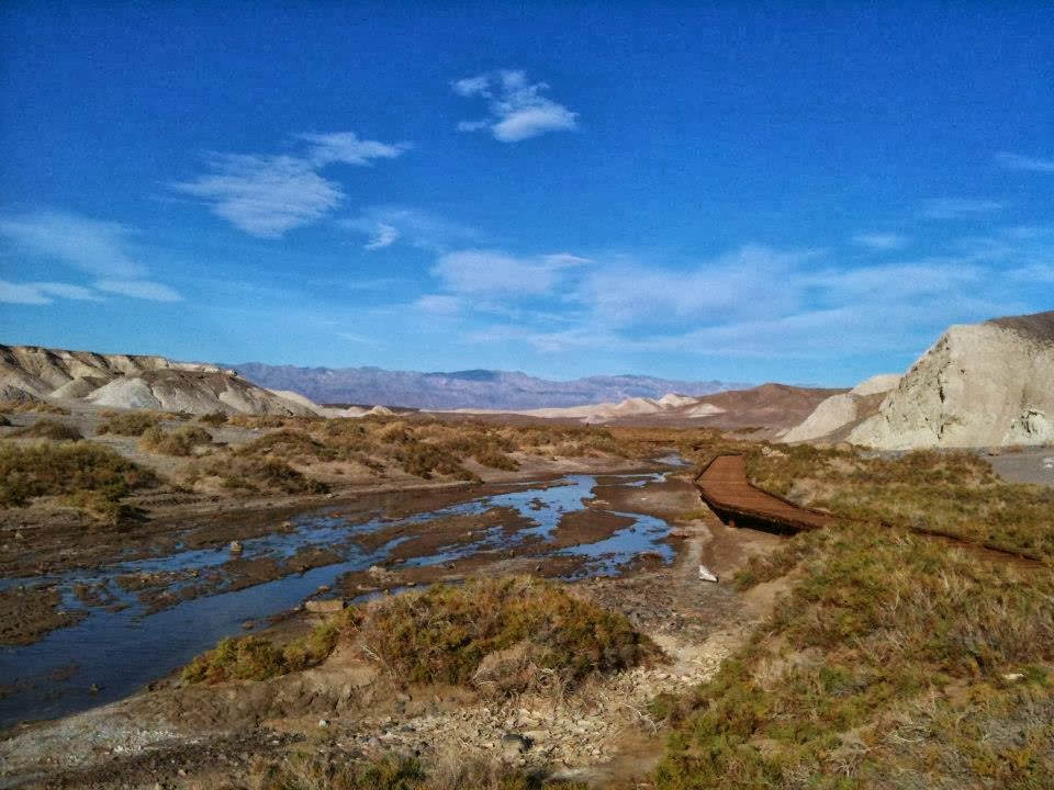
With that, we were off to our first stop, the Salt Creek Oasis, about 6 miles past the turnoff to Furnace Creek. Watch for the turnoff to your right when heading south. An underground spring makes this a rare sea of green in one of the driest places on earth. Animal sightings, including bobcats, coyotes, and rabbits, are common in this area; we saw many animal tracks, but they had already gone in to hiding for the day by the time we arrived.

(Note the jackets in the top photo; I don't recommend carrying one in the summer, but here in late November, early morning temperatures drop into the 50s, even below sea level.)
Next up was Mustard Canyon and the Harmony Borax Works historical site, just north of the Furnace Creek Visitor Center; when heading south, watch for the turnoff to your right. Borax (yes, the same mineral used in the cleaning powder/roach killer of the same name) used to be mined here, but the mines were abandoned years ago. Mustard Canyon itself is a collection of wind and water carved badlands; pretty enough, but since we had spent time exploring the similar Twenty Mule Team Canyon the day before, we decided not to stay long and continue on instead.


We made a brief stop at the Furnace Creek Resort for a late breakfast/brunch before continuing on (no facilities are available in the park south of Furnace Creek, and we didn't want to backtrack all the way back to get lunch later). The resort consists of two pieces - the resort itself, which is connected to the Furnace Creek Visitor Center, and the historic Furnace Creek Inn across the street, which is considerably more opulent (and expensive). All services are available here, including an 18-hole golf course, which claims to be the world's lowest at 214 feet below sea level. Furnace Creek is also where the highest temperature ever recorded in North America, and possibly the world, was observed on July 10, 1913, when the mercury hit 134 degrees Fahrenheit (57 degrees Centigrade). We headed over to the 49'er Cafe for our brunch. As you would expect from a National Park concession, the food was OK, albeit overpriced, though there is a nice view from the parking lot.

Our bellies full, we headed off to Zabriskie Point, an area that offers a unique contrast between the canyon landscape and Badwater Basin below. An easy path leads to a viewpoint, but just like other canyons in the park, those feeling adventurous can scamper up and down the badlands to find a better shot. To get to Zabriskie Point, after passing Furnace Creek, stay on Highway 190 instead of turning right on Badwater Road, and proceed about 3 miles to the turnoff on your right.


Our next stop was Golden Canyon. To get there from Zabriskie Point, go back towards Furnace Creek, turn left on Badwater Road, and watch for the signs about 2 miles on your left. NOTE: this is a popular hiking spot, and the small parking lot at the trailhead fills up fast, even during the shoulder season when we were there. Remember, though, that parking is allowed anywhere off the roads, unless marked otherwise, so just find a safe spot to pull off and you'll be fine. The Golden Canyon trail used to be a paved road, but was converted to only hike/bike use years ago. The narrow canyon contains brightly colored walls.


Now, it was time for the really good stuff. Our next stop was the Devil's Golf Course. No, it's not really a golf course, but is a natural formation that was reportedly given the name because "only the devil would play golf here". The Devil's Golf Course is a truly bizarre formation; salt from the salt flats has mixed over time with water, dirt, and other minerals to create barbed chunks of salt on the flat ground. You can walk on the Golf Course, but use extreme caution; the salt barbs are sharp, and can cut your hands or feet if you aren't careful. The Devil's Golf Course turnoff is located on Badwater Road, approximately 12 miles south of the turnoff at Furnace Creek. CAUTION: you'll have to travel approximately one mile on a rough, unpaved road. It is passable in a normal vehicle, but you will receive a complimentary back massage.


That left us with but one stop left in this great park, and that is its most famous attraction - Badwater Basin, the lowest point in North America at 282 feet below sea level. The Badwater Basin is actually a gigantic salt flat situated between the Panamint Range to the west, and the Amargosa Range to the west. Hiking is permitted anywhere in the Basin, but take precautions when doing so if you plan to stray very far from the main parking lot and boardwalk. One, it's easy to get lost in the flat expanse of salt, and two, even with the car's thermometer reading a pleasant 76 degrees on this November afternoon, the light and heat emanating from the white salt flats is intense. Wear sunglasses and a long-sleeve shirt and long pants to protect yourself from the sun, and carry plenty of water and a compass. If you get lost, just start walking east. You will eventually get back to Badwater Road, which you can then follow back to the parking lot. Also, don't panic if you feel your shoes falling through the salt crust. At most, it's a few inches deep, so while you will get annoyed and get some salt on the bottom of your pants, you won't get hurt.


After this incredible experience, we headed on out of the park. But as it turns out, we weren't quite done as far as things to see. Near the south exit of the park, we came across the ruins of the Ashford Mill, another abandoned mining site that also provided terrific views of the southern end of Death Valley.


And with that, I hope you enjoyed this virtual tour of Death Valley National Park. Keep reading this blog for more virtual tours in the future!
No comments:
Post a Comment