 |
| Badwater Basin in the distance |
Before we headed out for the day, we stepped outside to this beautiful view from our hotel room door:
Then it was off for a busy day of sightseeing. Our first stop was Mosaic Canyon, just a couple of miles from Stovepipe Wells, on the way to Panamint Springs.
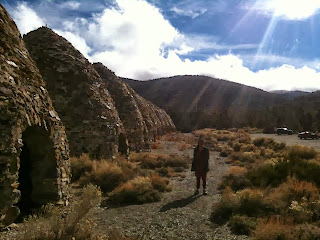
While pretty, the trail up the canyon became quite steep after about the first 1/2 mile, and with a lot of things to see before sunset, we decided to turn around and go back after just a short distance. We then headed to the Wildrose Charcoal Kilns, a pretty good distance away, which required backtracking almost all the way back to Panamint Springs, and then turning off on Emigrant Canyon Road. The last few miles of pavement are extremely steep, and the last mile is on a very rough, unpaved road (you can drive this portion in a regular passenger car, but you will get a full lower lumbar adjustment in the process). Here, due to the elevation of nearly 7,000 feet, the climate is cooler and wetter, and as a result, is pretty heavily forested. Trees from the nearby forest were burned in these kilns to make charcoal for the nearby metal mines. CAUTION: temperatures here can be 20-25 degrees colder than on the valley floor. In the fall and winter, dress accordingly, as it can be very cold.
On the way down, we caught a glimpse of Death Valley's version of fall foliage, on this lonely stand of cottonwood trees. NOTE: use caution when descending the hill - the steep grade will cause you to pick up speed quickly, even in first gear.
Once we were done here, we retraced our steps to Stovepipe Wells, and then headed up the Amargosa Range and Daylight Pass...
...to the old mining ghost town of Rhyolite, just across the Nevada border a few miles outside the town of Beatty. Rhyolite, like many towns before it in the Old West, endured a quick boom-bust cycle thanks to gold mining. The town was founded in 1904, grew to a population of perhaps as much as 5,000 by 1908, and was abandoned by 1916 once all of the gold was exhausted. Today, all that remains are the remnants of some of the town's buildings.
It was almost lunchtime, so we headed up the highway to Beatty to find something to eat. We settled on KC's Outpost Saloon and Eatery. Tasty homemade turkey sandwiches, friendly service, and homemade pies were on tap, and the whole thing set us back maybe $15. With full bellies, our next stop was Dante's View. If coming from Beatty, head back towards the park, take a left at the Beatty Cutoff, then left again at Highway 190. Continue about 10 miles past the Furnace Creek Visitor Center, and you'll see the sign for Dante's View. As you might expect from the name, this is a scenic viewpoint, at an elevation of about 5,500 feet, that provides sweeping views of the salt flats and Death Valley below. NOTE: prepare for cold, windy weather at this altitude in late fall and winter.
Next up was Twenty Mule Team Canyon, named after the company that makes Borax (the ingredient used in borax was mined in this area). The canyon is accessed by an unpaved road a few miles north of the Dante's View turnoff. The canyon consists of a series of multi-colored sandstone badlands formations in a dry creek bed. If you're feeling adventurous, you can scamper up the badlands; just beware that the sandstone is loose, so wear proper shoes.
With daylight running low, we hurried to Aritst's Palette (also known as Artist's Drive), which according to the park visitor guide, is best seen right at sunset, as the low sun angle produces vivid colors along the canyon walls. We managed to get to the entrance just as the sun was setting behind the Panamint Range to the west. Unfortunately, that meant we only had time to see the first viewpoint, and missed the best part of Artist's Drive further up the road, where green minerals in the rock supposedly create a stunning contrast with the red rocks due to sun's angle at sunset. Still, the first viewpoint was good for a couple of good photos. To get to Artist's Drive, go south on Badwater Road from Furnace Creek. You will see a sign on the left approximately 8 miles from the turnoff.
With no daylight left at this point, we headed back to Stovepipe Wells for one last night, before finishing up with the park the next day and heading back to LA. Look for the conclusion of this series next week!


No comments:
Post a Comment